Diana L. and I (this is Dwight writing this) spent the weekend in Pocahontas County, scouting Pocfest locations.
I drove from Baltimore, but with a stop in Culpeper, Virginia, so took the GPS-approved route of taking I-81 down to I-64, then west into West Virginia, then north on Highway 219. There are several ways getting to Pocahontas County from the north and east, and each one is gorgeous. I've grown fond of this route mostly largely because this is the way I came on my first trip to (I've been four times now), and I love the vistas and the farmland heading north at dusk. If anything it's almost too beautiful. I've posted a few pictures so you'll get the idea of what it looks like in Pocahontas County.
I drove from Baltimore, but with a stop in Culpeper, Virginia, so took the GPS-approved route of taking I-81 down to I-64, then west into West Virginia, then north on Highway 219. There are several ways getting to Pocahontas County from the north and east, and each one is gorgeous. I've grown fond of this route mostly largely because this is the way I came on my first trip to (I've been four times now), and I love the vistas and the farmland heading north at dusk. If anything it's almost too beautiful. I've posted a few pictures so you'll get the idea of what it looks like in Pocahontas County.

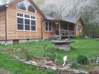
We stayed at Blue Lick Run, home of Pocfest hostess Brynn K., and the main site for 4th of July activities. Brynn has a charming house at the edge of the National Forest.
 RSS Feed